Papoose Lake - Sept 2011
We gathered our courage and planned a final trip into the Alps for 2011. Don Hook, Darrell Rainey, myself, Pedro and Charlie embarked from Hobo Gulch trailhead about noon. Mike Rainey came up later and made incredible time to catch us just at dark. Deer hunters had not yet arrived en masse and we really had the canyon to ourselves.

After about an hour and a half, we made it to the Rattlesnake Creek turnoff. Hiking was pleasant and not too hot. We were lucky to have an overcast day with spotty rain. 
The climb to this point is gradual, up and down and generally follows the North Fork of the Trinity River northward. Just north of the turnoff is a large horsecamp just across Rattlesnake Creek. Trailhead altitude is roughly 3000 ft elevation.
As we hiked up Rattlesnake Creek, immense and countless piles of stones left over from prior decades of mining work were evident. It is impossible to conceive how many backs were ruined moving all this rock! Perhaps 30 minutes up the creek from the turn-off there are 1-2 camp sites between the trail and the river (left side) that are generous and large. You might miss them if not alert. As we forded the river, we saw a sandy area as well that is marked as a campsite in some guidebooks, but is really not very pleasant. Another 20 minutes past the ford is a camp on the right, again, easy to miss. We saw it on the way out only because it was occupied by horses, hunters, a dog and plenty of brew.
The canyon gently ascends past oak forests. The next landmark is Bob's Farm Trail. The trail is deceiving and looks rather easy and inviting at the start! (Another day!) The trail now steepens and you head straight up at one point just prior to the ford of a river flowing down from Lois Lake. On the east side of this creek, follow the faint trail down the river about 25 yards to a very large, open, flat over-used campsite that does afford plenty of tent-space and a large fire-ring with stumps to sit on.
The next day, we made our way up the trail. The next creek to ford also contributes to Rattlesnake Creek, and comes down off the mountain to the north. There is a fairly large cleared campsite just along the far side of this creek that is pleasant.
It is right by the river among large boulders. Enni Camp follows about 30-45 minutes up the canyon. Steeper climbs are encountered at this point.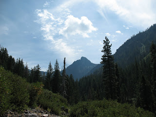
After Enni Camp, the trail is more difficult to follow and a few alternative routes are marked by hikers with cairns through dense brush for 1-2 miles. There is a good trail near the river by Enni Camp; we followed cairns left into the brush and did fine with lots of bushwhacking. The riverside trail affords a nicer walk for ½ mile or so. Stay with the cairns.

As you ford Rattlesnake Creek (didn’t see any by the way) this is your final place to resupply the water bottles before the lake. The last mile of the hike now rises 1200 feet, up rocky cliffs, across the hillside – from cairn to cairn.

The climb to this point is gradual, up and down and generally follows the North Fork of the Trinity River northward. Just north of the turnoff is a large horsecamp just across
 Rattlesnake Creek. Trailhead altitude is roughly 3000 ft elevation.
As we hiked up Rattlesnake Creek, immense and countless piles of stones left over from prior decades of mining work were evident. It is impossible to conceive how many backs were ruined moving all this rock! Perhaps 30 minutes up the creek from the turn-off there are 1-2 camp sites between the trail and the river (left side) that are generous and large. You might miss them if not alert. As we forded the river, we saw a sandy area as well that is marked as a campsite in some guidebooks, but is really not very pleasant. Another 20 minutes past the ford is a camp on the right, again, easy to miss. We saw it on the way out only because it was occupied by horses, hunters, a dog and plenty of brew.

The canyon gently ascends past oak forests. The next landmark is Bob's Farm Trail. The trail is deceiving and looks rather easy and inviting at the start! (Another day!) The trail now steepens and you head straight up at one point just prior to the ford of a river flowing down from Lois Lake. On the east side of this creek, follow the faint trail down the river about 25 yards to a very large, open, flat over-used campsite that does afford plenty of tent-space and a large fire-ring with stumps to sit on.
The next day, we made our way up the trail. The next creek to ford also contributes to Rattlesnake Creek, and comes down off the mountain to the north. There is a fairly large cleared campsite just along the far side of this creek that is pleasant.
It is right by the river among large boulders. Enni Camp follows about 30-45 minutes up the canyon. Steeper climbs are encountered at this point.

After Enni Camp, the trail is more difficult to follow and a few alternative routes are marked by hikers with cairns through dense brush for 1-2 miles. There is a good trail near the river by Enni Camp; we followed cairns left into the brush and did fine with lots of bushwhacking. The riverside trail affords a nicer walk for ½ mile or so. Stay with the cairns.


As you ford Rattlesnake Creek (didn’t see any by the way) this is your final place to resupply the water bottles before the lake. The last mile of the hike now rises 1200 feet, up rocky cliffs, across the hillside – from cairn to cairn.

The trail veers left to the canyon with the river cascading far below. This section is dangerous and must be very carefully traversed. The gorge must be 300 feet deep and one big cliff; a misstep here would mean the end of the trip – in more ways than one. Be careful;
watch younger hikers very closely here!
watch younger hikers very closely here!

Papoose Lake is the quintessential Trinity Alps lake – beautiful, glistening, surrounded by beautiful granite and a high granite crown of magnificent circ. Papoose is unique in that the circ is half granite and half volcanic, and the dividing line is clearly visible. This circ is the most majestic I have seen in the Alps. Close to 180 degrees; last year’s snow still visible on the northern slopes even in September.

The group was very patient with dutch oven recipes; most were fine, but a few were less that perfect. Usually lacking enough coals to cook briskly. 
There is a well used campsite near the lake outlet, among boulders – pictured here. Very nice.

There is a well used campsite near the lake outlet, among boulders – pictured here.
 Very nice.
 As you explore the western edge of the lake, there are several exposed sites with firerings on the rock. In the small pine cluster at the southwestern corner of the lake, there appeared to be a very nice campsite. 
The next morning was beautiful and brisk. The sun took a long time to visit us in this circ. Animals and people were happy to reach water at the base of the canyon again. The way out is a gentle and occasionally steeper, gradually decline over several miles. Two days before the annual deer –hunt provided for lots of company as we made our way out. Almost a highway really.
We had intended to make camp near the Rattlesnake Canyon junction, but all campsites were full of hunters. We voted and hiked all the way out in one day. 14 pleasant, beautiful miles!
A highly recommended, at times strenuous hike, Papoose is relatively lonely – except during the annual September deer hunt! Clearly in the top 5 of the Alps for scenery and beauty.
Bob’s Farm Trail remains a great mystery and a likely goal for 2012; Papoose, Bob's Farm, Grizzly Lake! Pedro and Charlie will have to get in shape for that one....
