One trip to Grizzly Lake this year just wasn't
enough. Bishop Hook and his son, Cory, from
Florida came and made a threesome. It was great!
We packed the goats and tried to keep our packs
lighter.


 We hiked from the China Creek trailhead near Cecilville. You head west off of I-5 through Gazelle to Callahan, and bear west over the bridge in the middle of town. The trailhead embarks at about 4500' elevation, and takes a mile to climb 1500 feet. Then you descent 1500 feet in another mile.

enough. Bishop Hook and his son, Cory, from
Florida came and made a threesome. It was great!
We packed the goats and tried to keep our packs
lighter.

 We hiked from the China Creek trailhead near Cecilville. You head west off of I-5 through Gazelle to Callahan, and bear west over the bridge in the middle of town. The trailhead embarks at about 4500' elevation, and takes a mile to climb 1500 feet. Then you descent 1500 feet in another mile.
The trail joins the Hobo Gulch route and gradually ascends 4 miles or so back up to 6000' at Grizzly Meadow. We had a great campsite and the Hooks were very patient with my recipes in the dutch oven - which, for the most part turned out tolerably well.

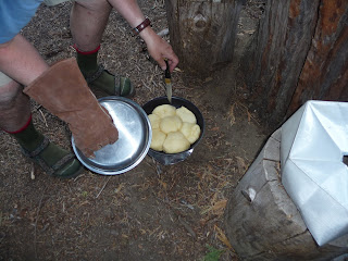
 Temperatures were unseasonably warm for September. The foliage bore traces of early fall changes and the water levels were significantly below July levels. Some creeks were dry, and others were now ponds. Nightime was 60 F and warm. Breakfast was a combo of breakfast potatoes, smokie sausage, egg and cheese in the dutch oven. Then we set off to see Grizzly Lake and attack the scramble leading to it. The picture above is taken from the scramble and shows the amazing rugged nature of the white alps.


 Corey (below right) is standing on the edge of an 200' cliff and another 500' of rock. The outlet of the waterfall and the "jump" you have to make is beneath him on the right.
Corey and I and Pedro and Charlie (caprine companions) then headed for the summit of Thompson Peak.


 We headed up the forested area just west of the ravine south of the lake. Then skirted across the scramble beneath the cliff and up to the saddle. The way to the peak from there is vague. You seem to drop down the other side about 100 yards and proceed east. Many spurious paths lead up to the crest of the ridge, but not to the peak. You finally reach about a 20' pile of rock which requires true rock climbing to get to the peak. Corey made it, but the goats didn't, so we took some pictures of the drainages nearby and headed back to the saddle.

 After a big day, we rested well. Dinner was a casserole of cream corn, brocolli and chicken! Goatpacking does let you eat a bit better than the usual dehydrated fare.
The lake and circ were brilliant with early fall colors; fishing appeared lively and the water was, as usual, ice cold and incredibly clear.


I think Papoose Lake looks good for 2010!

 Temperatures were unseasonably warm for September. The foliage bore traces of early fall changes and the water levels were significantly below July levels. Some creeks were dry, and others were now ponds. Nightime was 60 F and warm. Breakfast was a combo of breakfast potatoes, smokie sausage, egg and cheese in the dutch oven. Then we set off to see Grizzly Lake and attack the scramble leading to it. The picture above is taken from the scramble and shows the amazing rugged nature of the white alps.

 Corey (below right) is standing on the edge of an 200' cliff and another 500' of rock. The outlet of the waterfall and the "jump" you have to make is beneath him on the right.
Corey and I and Pedro and Charlie (caprine companions) then headed for the summit of Thompson Peak.


 We headed up the forested area just west of the ravine south of the lake. Then skirted across the scramble beneath the cliff and up to the saddle. The way to the peak from there is vague. You seem to drop down the other side about 100 yards and proceed east. Many spurious paths lead up to the crest of the ridge, but not to the peak. You finally reach about a 20' pile of rock which requires true rock climbing to get to the peak. Corey made it, but the goats didn't, so we took some pictures of the drainages nearby and headed back to the saddle.
 To the right is Canyon Creek drainage and a shot of Wedding Cake. To the upper right is Stuart Fork drainage and Caribou Mountain. On the right is a shot along the ridge to the point of Thompson Peak, noting the glacier with crevasses below it.
Time from the lake to peak and back to meadow
Time from the lake to peak and back to meadow
was 6 hours.

 After a big day, we rested well. Dinner was a casserole of cream corn, brocolli and chicken! Goatpacking does let you eat a bit better than the usual dehydrated fare.
 The next morning, we packed up and out. Down the hill, up the hill and back down the hill! The goats were doing 30lbs and panted their way up but never gave it up. Hooray for alpine goats. Our prior Nubian buddy was wont to lay in the trail, and never could have gotten close to this one.
The lake and circ were brilliant with early fall colors; fishing appeared lively and the water was, as usual, ice cold and incredibly clear.

I think Papoose Lake looks good for 2010!


 From here the trail ascends up the south-facing slope of Grizzly Canyon fairly continuously with a few switchbacks through oak and other deciduous trees. This stretch is a good morning hike as the lower altitude lends to hot afternoons - especially facing south. There is a great little campsite at the junction of the ______ trail with a nice small creek. Bob's Farm trail angles off to the south before you reach the junction of China Creek T
 Grizzly Meadows is an Eden-like beautiful meadow and forest surrounded on three sides by high canyon cliffs. The waterfall graces the eastern end of the canyon and is always heard. There is a nice small campsite at the western entrance of the meadow, with a handy, pretty creek. Not too private however, as the trail goes right throught the middle.


 Jorstad Cabin was a welcome sight, with its benches, tables, firepit and swimming-hole. The water has warmed quite a bit in the sun during the last 10 miles or so; it is an excellent place to cool off and wash off. I am amazed that Mr and Mrs Jorstad put up with 24/7 river noise! Probably tuned it out over time. The sound of tumbling river rocks when all else is quiet sounds amazingly like a crowd of people conversing. Many times I looked up and expected to see a group of hikers approaching.